Advances NSW Gold and Base Metals IPO
Perth, April 29, 2019 AEST (ABN Newswire) - Ardea's ( ASX:ARL) (
 ARRRF:OTCMKTS) spin-out of the New South Wales (NSW) assets via an Initial Public Offer (IPO) is advancing, with technical reviews and field programs confirming high prospectivity mineral targets across the IPO tenure.
- Lewis Ponds - surface mapping completed with database compilation being finalised to enable an updated resource estimate to be completed following JORC Code 2012 guidelines.
- Copper Hill East - zoned copper anomaly exceeding 200ppm associated with a likely dioritic intrusive complex, good analogy to the Copper Hill porphyry copper deposit located 15km east.
- Mt Aubrey - high priority epithermal gold system identified in historic drill data with target confirmed by Ardea soil auger program (geochemical anomalies up to 103ppb gold). Porphyry molybdenum target defined with anomalies up to 108ppm molybdenum. Additional tenure applied for covering mineralisation strike extension.
- Yeoval - high priority porphyry copper system confirmed by soil auger geochemical anomalies up to 1,720ppm copper.
- Gundagai - gold-copper system confirmed by soil auger geochemical anomalies up to 94ppb gold and 767ppm copper, localised within broader 0.2% manganese halo.
Broker discussions underway to support IPO
Chief Executive Officer, Andrew Penkethman, on reviewing Ardea's NSW projects stated:
"The IPO of our NSW assets is a part of Ardea's three-pronged value creation strategy. This prospective 2,000km2 of gold and base metal tenure across our 100% controlled NSW projects will underpin a dedicated IPO, with distribution of free in specie shares to Ardea Shareholders.
The IPO is advancing as planned, with target definition followed by on-ground exploration completed over key components of each project area.
Initial results are highly encouraging and have confirmed multiple base and precious metal targets, which highlight the prospectivity of the NSW project portfolio with follow up programs planned to test these targets post IPO."
NSW Gold and Base metals projects
Ardea Resources Limited ("Ardea" or "the Company") planned spin out of its NSW mineral assets remains on track with a prospectus to be lodged in H2, 2019.
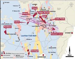
Ardea controls a suite of highly-prospective tenements in NSW within the Lachlan Fold Belt (see Figure 1 in link below) which hosts multiple bulk-tonnage deposits such as Northparkes, Cadia-Ridgeway and Cowal.
Data validation is underway for the Lewis Ponds gold-base metal project with resource estimation to follow. The Mount Aubrey epithermal Au project has had a 3D model completed for historic gold drilling, while at the Yeoval, Copper Hill East, Ophir and Wiseman's Creek projects located on the Lachlan Transverse Zone and at Gundagai, historic exploration data has been compiled. Where land access was secured, vehicle mounted soil auger or conventional manual soil geochemistry has been completed with a view to defining drill targets. Data compilation is current at Calarie and Restdown, and land access negotiations have commenced.
Lewis Ponds, NSW
Lewis Ponds, Ophir and Copper Hill East gold-base metal project - EL5583, 8323 and 8556 (100% Ardea)
These projects cover a 50km strike length of the highly prospective Godolphin-Copperhania Thrust, which hosts Volcanogenic Massive Sulphide (VMS) base metal deposits notably at Lewis Ponds and significant orogenic shear-hosted gold deposits including the McPhillamys deposit some 20km south of Lewis Ponds.
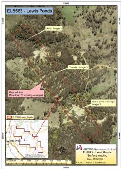
Surface mapping has confirmed historic workings were generally located on linear mineralised zones. All workings on the western mineralised units from the Lewis Ponds smelter, some 800m south to the historic Tom's Lode workings, were mapped. More than 75 workings of differing mineralisation styles were mapped (see examples shown in Figures 2 to 4 and reference plan, Figure 5)(see link below). The physical characteristics of the mineralised units as well as the dimensions and orientation of the workings play a key role in understanding and developing the revised Lewis Ponds 3D geological model.
All historic Lewis Ponds hard-copy drill data was recently located, acquired and digitised to enable the most accurate re-interpretation possible of Lewis Ponds as a bulk-tonnage system.
The Lewis Ponds database compilation has proved challenging, with some historic holes geologically logged up to four times often with differing geology rock-codes, which requires consolidation into Ardea's single digital database. The aim is to complete the new resource estimation to JORC-2012 requirements.
Copper Hill East
The geological setting is favourable, being Macquarie Arc andesite (Fairbridge Volcanics). The aim is to locate porphyry copper style intrusives of the Copper Hill deposit style which is located 15km west.
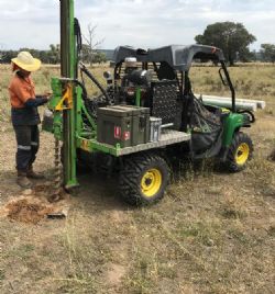
The terrain encountered on the Copper Hill East tenement is a mix of steep hills and flat pasture land. The level ground was sampled by vehicle-mounted soil auger allowing the sample to penetrate below any transported material and providing a representative analysis of bedrock. The steeper hills could not be traversed with an auger rig and were thus sampled manually ensuring the sample was either taken in the "C" horizon or where the hole intersected bedrock and in so doing ensuring consistency with the auger in terms of sampling medium. Outcrops of diorite porphyry with occurrences of secondary copper oxide minerals, malachite and azurite, were noted while doing initial reconnaissance in the area.
Soil auger geochemistry (see Figure 6 and 7 in link below) defined a zoned copper anomaly exceeding 200ppm associated with an interpreted dioritic intrusive complex. Sample assay results taken in hilly areas have not yet been received.
On receipt of all results, geophysical modelling is planned in order to generate drilling targets.
Mt Aubrey epithermal gold-silver project - EL8532 (100% Ardea)
Mt Aubrey is located at the east contact of the highly mineralised Macquarie Arc Ordovician andesites some 30km northeast of Parkes and 30km southeast of the historic Peak Hill epithermal gold mine.
Mt Aubrey was acquired by Ardea as an epithermal gold system. Gold mineralisation is typically hosted by 0.5-3m thick chalcedonic epithermal quartz veins and stockworks. The site was mined via a number of shallow open pit gold-mines in the late 1980s.
Initial reconnaissance at the Mount Aubrey prospect located three back-filled historic pits, confirmed by ground subsidence of up to 2m around the periphery of the pit. The pit area is also characterised by a slight rise in topography and scattered quartz vein float. The quartz shows clear bladed calcite-lattice texture and is sometimes stained by pyrite, confirming an epithermal style.
Outcrops are limited due to alluvial cover. Few historic workings could be recognised due to the extensive earthmoving during the mine production phase. Workings were however identified on a neighbouring property along strike of the Mount Aubrey mineralisation on EL8532. These workings are also situated on a topographic rise and quartz float is common. The outcropping rocks show evidence of silicic and/or phyllic alteration. This area has not yet been sampled by Ardea, with follow up field work planned.
A historical data review was completed for the Mount Aubrey epithermal gold vein system. End of mine open pit surveys appear not to have been provided to the government, so have yet to be located. These are required to account for the material mined, so a resource following JORC 2012 guide lines cannot yet be defined.
Ardea is targeting a JORC 2012 compliant resource in the future by completing confirmatory RC drilling and a ground penetrating radar survey to define the back-filled open pits.
Soil auger drilling (see Figure 8, 9 and 10 in link below) was completed on targets defined from Ardea's compilation of historic work, with multiple anomalies defined in preliminary results (refer Appendix for JORC 2012 Table 1 Sampling Techniques and Reporting).
Ground truthing and follow up of targets is planned:
- Samples ARMA190061-077, Epithermal Gold, 22-103ppb Au, 51-155ppm As, 3.8-10.7ppm Sb, 40-92ppm Cu, 50-191ppm Zn, 250-920ppm Mn, associated with strongly chlorite-altered basalt.
- Sample ARMA190109, Epithermal Gold, 80ppb Au, 129ppm As, 14.6ppm Sb, associated with strongly chlorite-altered basalt.
Base metal targets were defined peripheral to the gold targets:
- Samples ARMA190118-121, Epithermal Zinc-REE, 116-204ppm Zn, 0.3-0.8ppm Ge, 267-500ppm Ce, 99-350ppm La, associated with strongly sericite-altered rhyolite.
- Samples ARMA190130-131, Epithermal Zinc-REE, 146-202ppm Zn, 0.2-0.4ppm Ge, 159-500ppm Ce, 93-231ppm La, associated with strongly sericite-altered rhyolite.
A high priority molybdenum target was generated at Emu Swamp east of the Mount Aubrey pits. Samples ARMA190206-217, interpreted as a Porphyry Molybdenum target, ranged from 8-108ppm Mo, 0.2-0.9g/t Ag, 40-237ppm As, 54-209ppm Zn, 244-500ppm Ce and were associated with strongly sericite-altered rhyolite.
Additional tenure was applied for to cover the eastern strike extension of the Emu Swamp target.
Yeoval Porphyry copper-gold-molybdenum-rhenium project - EL8538 (100% Ardea)
Yeoval is located within the Macquarie Arc, 60km northeast of the Northparkes copper-gold mine. The tenement covers an area of 138km2 and is intensely mineralised with more than 60 historic copper workings trending in a north-easterly direction along a 20km strike. The Ardea exploration concept is a large tonnage porphyry copper-gold-molybdenum-rhenium system.
The Cuga Burga Volcanics represent the extrusive phase of the Yeoval Igneous Complex and have potential to contain porphyry copper-molybdenum-gold mineralisation.
Ardea sampling has focussed on copper mineralisation at Vaughan's Ridge, associated with a series of hydrothermally altered andesitic volcanics and granodiorite or quartz diorite (see Figure 11 in link below).
At the Obley Gossan locality within the soil anomaly there is extensive silica-sericite-pyrite alteration and near the Ironbark Hill locality there is a leached capping within strongly weathered fine grained volcanics.
This is all typical of the upper level phyllic alteration zone of a porphyry copper system, and augurs well for the main target style at depth, being the potassic alteration zone.
Soil auger geochemistry was completed over a 2km N-S strike covering small historic copper workings. Ardea rock-chip sampling of 16 representative rocks returned up to 0.47% Cu with variously 1.7g/t Ag, 59ppm Mo, 99ppm W, 42ppm Se and 27ppm Se. This is a typical porphyry copper metal suite.
The initial soil auger geochemistry results at Yeoval (see Figure 12 and 13 in link below) returned a strong anomaly of up to 1,720ppm Cu, with variously 23ppb Au and 9ppm Mo, associated with strongly chlorite-calcite-pyrite altered basalt within the predominant felsic sequence. The copper often has anomalous silver at its margin, up to 1230ppb, giving the impression of a large zoned alteration system. There is also anomalous Se to 30ppm and Te to 10.7ppm, suggesting a higher level "epithermal" setting.
The copper anomaly has a N-S strike of 1,920m and width of 560-1,120m, so has the potential for a bulk tonnage copper system. The specific target being explored for is a deep potassic alteration system, rather than the predominantly upper level chlorite-calcite dominant propylitic and phyllic system as seen in Yeoval outcrop and within the multi-element rock and soil auger data.
There are desultory historic drill holes present within the anomaly, which have copper anomalism but not bulk tonnage intercepts, so do not reflect the observed soil anomaly.
Wiseman's Creek gold-copper project - EL8554 (100% Ardea)
Wiseman's Creek is located 35km southeast of Bathurst, NSW, around the logging town of Oberon. Epithermal gold mineralisation within the tenure is hosted largely within Late Silurian to Early Devonian-aged sediments, with geology through the centre of the tenure comprising the andesitic Ordovician-aged Rockley Volcanics (equivalent units host the Cadia and Northparkes gold-copper operations).
The Exploration Licence has several State Forests and these in turn host many of the historic mineralised sites. The Right to Negotiate process for access to Crown Land has commenced. Once this process is completed and access granted, Ardea can commence work in the most prospective areas.
Gundagai gold-copper project - EL8061 & 8586 (100% Ardea)
The Gundagai tenements are located 315km southwest of Sydney. Several old gold workings hosted by mineralised porphyry units exist in the Ardea tenure (see Figure 14 in link below), with historic RC drilling at Big Ben returning up to 20 metres at 1.58g/t gold within a quartz-limonite-pyrolusite stockworks system. The Big Ben mineralised system is open to the south, under alluvial cover. Previous historic soil sampling located a >100ppb Au anomaly associated with and also to the east of the Big Ben mineralisation.
The topography of the Gundagai South exploration licence is generally very steep. Reconnaissance exploration identified 34 historic workings (see Figure 14, 15 and 16 in link below) in three main areas and an additional site to the east. This newly discovered eastern set of workings (see Figure 14 in link below) seems deeper and more substantial that those mapped in the soil sampling areas and will be sampled in the future.
Based on the Big Ben mineralisation style and the potential for a large-scale system, Ardea has completed soil auger drilling over defined targets.
Big Ben East
Preliminary Ardea soil auger results were interpreted, confirming several felsic-hosted gold-copper targets (see Figure 17 and 18 in link below).
Ground truthing and follow up of targets is planned, focussed on the following sample sites:
- ARGS190059, 060 up to 53ppb Au, 0.7g/t Ag, 0.7ppm Te, 140ppm Cu, 114ppm Pb, 0.08% S
- ARGS190067, 069 up to 78ppb Au, 0.6g/t Ag, 1.0ppm Te, 184ppm Cu, 0.10% S
- ARGS190114 94ppb Au
- ARGS190115-117 up to 767ppm Cu, 140ppm Zn,
- ARGS190173 61ppb Au
The Big Ben East soil gold anomaly is comparable to the Big Ben anomaly, which has the historic mineralised drill intercepts. Big Ben East accordingly is a walk-up drill target.
Of particular interest, is very strong pyrolusite (manganese oxide) associated with the outcropping Big Ben mineralisation. Ardea's auger geochemistry records very high manganese backgrounds uniformly throughout the entire Gundagai sampled area. This may be a significant pathfinder as a halo to deeper gold mineralisation and will be investigated during follow-up work.
To view figures, please visit:
http://abnnewswire.net/lnk/WMR55161
About Ardea Resources Ltd
 Ardea Resources Ltd (ASX:ARL) (OTCMKTS:ARRRF) (FRA:A91) is an ASX listed resources company, with 100% controlled Australian based projects, prioritising a three-pronged value creation strategy which is:
- development of the Goongarrie Nickel Cobalt Project, which is part of the Kalgoorlie Nickel Project, a globally significant series of nickel-cobalt deposits which host the largest nickel-cobalt resource in the developed world, coincidentally located as a cover sequence overlying fertile orogenic gold targets;
- advanced-stage exploration at WA gold and nickel sulphide targets within the Eastern Goldfields world-class nickel-gold province; and
- the demerger of the NSW gold and base metal assets with planned in-specie share distribution, with projects located within the Lachlan Fold Belt world-class gold-copper province.
| ||
|


