Company resources grow to 137 million tonnes
Binjour Resources Increase to 37 Million Tonnes
Sydney, June 18, 2018 AEST (ABN Newswire) - Emerging bauxite producer, Australian Bauxite Limited ( ASX:ABX) (ABx) holds tenements covering the core of the Eastern Australian Bauxite Province (see Figure 6 in link below). ABx considers its Binjour Project located 115kms southwest of Bundaberg Port (see Figure 1 in link below) to be a discovery of a major bauxite province which is being assessed to become the company's flagship project over the next 5 years. Resource estimations are confirming the significant potential of Binjour.
- 37 million tonnes of thick, gibbsite trihydrate bauxite resources at Binjour, central QLD
- Based on 930 drill holes into approximately 75% of the identified bauxite layer that extends over 44 square kilometre Binjour Plateau (see Figure 2 in link below)
A 3 to 15 metres thick layer of bauxite extends over the entire 44 square kilometre Binjour Plateau (see Figure 2 in link below). Parts of this bauxite layer totalling 10.4 million tonnes is suitable for simple bulkmining and shipping as "DSO Bauxite 1" whilst other areas totalling 26.6 million tonnes contain silica gel veinlets which require processing with ABx's proprietary TasTech technology to reduce silica and upgrade the Al2O3 content to meet the target production grade.
Mine planning and scheduling is in progress to determine the optimum mining and processing needed to achieve the two main Binjour Products, the grades of which have been established by a bulk sampling program that subsampled 2,000 tonnes of drillhole samples in December 2017.
Resource Estimation Details
1. Location
Binjour Bauxite Project lies on a plateau located 115kms WSW from Bundaberg Export Port, in the Wide Bay Burnett Region of central Queensland, Australia. It is the best located of perhaps 5 projects in this region that may total in the order of 200 million tonnes of trihydrate gibbsite bauxite.
2. Logistics: Product Transport Route
Road Transport: A transport study is in progress by two land transport operators and involving discussions with government transport officers. The main destination focus is the Port of Bundaberg. Discussions with QLD transport department officers are well advanced.
All roads are gazetted major highways but have axle loading constraints and total truck tonnage restrictions on certain bridges, as is normal in Queensland. Trucking from Binjour to the Port of Bundaberg ranges from 188km to 198km.
Port Bundaberg is a river port with inner port restrictions of 200 x 32 metre ship sizes due to swing basin limits and a 9.5 metre channel depth (11m at the loading pocket) at the lowest astronomical tide. However, studies of potential barge transhipment and loading onto Cape Size ships within the outer port limits are being studied in detail
Port Bundaberg connects directly to deepwater shipping routes via well-defined shipping channels with shifting sand seafloors. The shipping channels are located well south of the Great Barrier Reef and will have zero impact on it.
3. Tenement Holdings
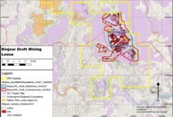
ABx has two granted exploration permits-mining EPM 18014 Binjour and EPM 18772 Binjour Extension covering the Binjour Plateau. Resources estimated and reported herein are all in EPM 18014 as shown in Figure 2 above (see link below). All tenements are in good standing and are unencumbered.
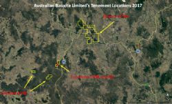
Other tenements in the area are shown in Figure 3 (see link below) following and include a granted Mining Lease at Toondoon 25km south of Binjour and exploration tenements (EPMs) at Toodoon and Brovinia.
4. Land Status
The Binjour Bauxite Deposit occurs on land comprising freehold farms and lesser State Forest areas. It is not considered strategic cropping land but that will require confirmation in due course.
Native title applies to two small forestry reserve areas that may not be alienated land, covering approximately 7% of the bauxite resources. These can be excluded from any initial mining lease application should they prove to be native title so as to avoid undue project delays.
5. Geology
The district was subject to extensive tertiary alkali-basalt volcanic activity followed by deep weathering and topographic inversion (see Figure 5 overleaf in link below). A residual bauxite layer covers the main topographic high, Binjour Plateau. The Bauxite is interpreted to have been deposited as a flat lying of volcanic tuffaceous origin. This strata has been preserved on a series of plateaus which are remnants of an old peneplain surface.
Most bauxite lies beneath a soft, dry red mud horizon of variable thickness (typically 6m to 8m). Much of the high grade bauxite occurs in lenses and bands. Some bauxite zones are considered best suited to cement-grade because of intergranular clay veins (often halloysite-clay) but ABx's proprietary TasTech processing technology may increase yields of metallurgical grade bauxite. Bauxite occurs in both nodular and massive forms with the nodular bauxite sitting directly above the massive bauxite.
Underlying the bauxite is another mottled clay-mud unit which is probably more than 70m thick.
The bauxite generally outcrops on the edges of slopes and has been inferred to be the result of weathering around the edge of the plateau. Good continuity of the bauxite layer is displayed away from the outcropping bauxite, with the same layer being intercepted under the red clay layer well into the plateau.
Because of concealment by the upper mud clay layer there is significant potential for the discovery of additional bauxite resources both at Binjour and regionally.
Regional bauxite province: A province of bauxite deposits of various sizes on bauxite-hosting plateau extend south-south-westwards from Binjour Plateau for over 100kms - see Figure 1 above (see link below).
6. Resource Estimation
Drill Statistics
A total of 930 RC aircore holes have been drilled for 19,098m (average depth 20.5 metres). 30 of these holes are excluded from the database because they were either not on EPM 18014 or were for non-resource purposes. For resource estimation, the results from the 900 aircore holes totalling 18,599m (average depth 20.7m) on EPM 18014 were extracted from the ABx master database system called ABacus.
In addition, a 6-hole diamond drilling program was done at the end of the aircore drilling programs to assess the geological profile, collect samples for microscopy, petrology, mineralogy and density determinations by gravimetric methods (see below).
Drilling procedure and sample recovery
Drilling was undertaken using a light truck mounted reverse circulation rig using compressed air and drilling using the air core method. The rig operates with twin rear wide tyres for low ground pressure and minimal ground disturbance. The rig is fully contained carrying 3m rods and a compressor on board. A field support vehicle is required for mobility.
Drilling is conducted in a semi-random pattern largely governed by access and site availability. Drill spacing is typically between 75m and 150m. Drill chip recovery is extremely consistent at Binjour, mainly because of dry ground conditions above and through the bauxite layer. If the sample recovery was deemed to be significantly lower than expected, the hole was abandoned and a new hole started nearby.
Location of data points
All drill hole locations were surveyed at the time of drilling using hand held GPS, with accuracy of +/-5m. Topographic control was assessed using data from the 3 second SRTM derived digital elevation model. This procedure gives adequate accuracy for the level of the resource which has been defined using inverse distance squared grade interpolation in a 2-dimensional plan projection and confirmed by other methods.
Sampling technique
Samples were collected at metre intervals and assessed by the geologist on site. All samples suspected of containing bauxite were split from the main sample bag using a broad headed, flat based shovel and placed in a calico bag for testing at ALS Laboratory in Brisbane.
A sub sample is also taken to be tested with the company's own mobile XRF device for rapid results, mainly silica determination. The mobile XRF results are used to lead further drilling.
A small grab sample of each 1 metre long sample is also added into a plastic mud-logger's chip tray. The remainder of the sample is stored in a secure lockup rented from the Forestry Department. All non-bauxite sample intervals are also stored at the lockup. All samples are stored in a neatly ordered pallet system allow-ing for easy recovery of every sample drilled.
Logging and lithology
Each metre interval is described in the field by colour, texture, lithology, apparent moisture and lumpiness (assessed visually). A brief description of the sample may also be written if there are interesting or distin-guishing features that need to be recorded separately from the ABx coding system. Each sample, chip tray, and hole rehabilitation is photographed for record keeping and review. 100% of the samples are logged.
The computerised logging information, scans of the had-written log sheets, photos of all samples and the drillhole itself before drilling and after rehabilitation are stored in ABx's proprietary database called ABacus so as to allow real-time inspection of any information (see Data storage below).
Quality of assay data and laboratory tests.
The Assay work was completed at a fully certified ALS laboratory in Brisbane, Australia. For Standard XRF runs there was a minimum of 1 Blank, 2 Standards and 2 Duplicates per 43 Regular samples. For available Al2O3 and reactive SiO2 there was 1 Blank, 3 Standards and 2 Duplicates for 42 Regular samples. For the LOIs, there was 1 Standard and 1 Duplicate per 19 Regular samples. Leach conditions to measure available alumina "Avl Al2O3" and reactive silica "Rx SiO2" were 1g leached in 10ml of 90gpl NaOH at143 degrees C for 30 minutes.
Resource Continuity
Comparisons of results from twinned holes (Levy, June 2012 "Twinned Holes Report Jun12.doc") suggest that the repeatability or "precision" of individual metre samples is low, probably due to the combined effects of variations in sieving yields in the laboratory and variable quality distributions throughout the bauxite hori-zon. This is not unusual for bauxite.
However, average grades of the full drill intercepts thicknesses and grades display a greater degree of short-distance continuity or "precision", probably due to random imprecision factors that average-out over the full bauxite intercept.
This supports the use of resource estimation methods which use full bauxite intercepts as the data points for block modelling, rather than block-modelling methods based on individual metre samples as the data points.
Data storage and database integrity
All assay, lithology, and collar data is securely stored on a proprietary Microsoft Access database system known as ABacus. ABacus has been specifically tailored for ABx by consultants GR-FX Pty Limited. The Database has inbuilt checks to ensure database integrity.
All data is checked to ensure it belongs to a valid hole, and that all sample numbers belong to a valid logged sample number that has been entered into the database.
Paper logs can be displayed on screen with the digital data for further verification. The assay data is verified by checking that the totals of at least three different analysis sum to the same total as the original file pro-vided by the laboratory.
A photo of every sample, chip tray, hole rehabilitation, and scanned log sheet is also stored in the ABacus database. All hand written field logs are digitised by a trained database technician. The digital version is then double checked by the relevant geologist to ensure consistency.
Block Modelling
Resources estimation modelling was undertaken by Scandus Pty Ltd using intercept data provided by ABx. A cross-check estimation was done using a polygonal method which achieved satisfactorily similar results.
The Binjour data was provided to Scandus as intercepts (true width), thickness and assays (for sieved 0.26mm material) and ratios (Avl/Srx, A/S, Waste/Bauxite, Al2O3, avl Al2O3, LOI, SiO2, SiO2rx, TiO2, Fe2O3, thickness of Bauxite and Yield) as length weighted averages, and depth to bottom of overburden.
25x25m Blocks were created in the east and north orientation and the Z value was a nominal 5 m, however the z value was replaced with modelled thickness for volume determinations similar to seam modelling. Polygons were then created to constrain the model, these polygons were drawn based on geological knowledge of the deposit style and topographic constrains. The block model was coded with 'rock type' based on the blocks contained in the provided polygons, as were the intercepts. The estimation was carried out using Inverse Distance Squared, no top cut was used. A search ellipse of 400x400m with a minimum of 1 sample and maximum of 12 samples was used to estimate blocks to the edges of the observed geological/ ore boundary.
This search ellipse was deemed adequate based on variogram analysis which indicated geostatistical continuity at this distance. Confidence in this distance is further strengthened when the geological model for this deposit indicates good horizontal continuity.
The number of samples used in the estimation of each block was recorded as was the distance to the closest sample from the estimated block and this information is used to help classify the blocks. Blocks with fewer than 3 samples (ie. 3 holes) were then removed from the model. Blocks with between 3 and 9 data points were classified as being inferred resources, and blocks with over 9 samples being classified as indicated.
All assays, ratios, thickness Overburden and included dilution were modelled using the same parameters.
In-Situ Bulk Dry Density
An average of 1.9 t/m3 Specific Gravity was used to convert Volumes to Tonnes. This value was calculated by gravimetric and water displacement density testing methods based on samples collected from diamond drill core from a 6 hole diamond drilling program (Roach, 2012, "Core Program_Report_26102012_blr.doc"). Results are summarised below: (see link below)
To view the release with tables and figures, please visit:
http://abnnewswire.net/lnk/PC861P3H
About ABx Group Limited
 ABx Group Limited (ABx) (ASX:ABX) has its first bauxite mine in Tasmania & controls the Eastern Australian Bauxite Province. ABx's 11 bauxite tenements in Queensland, New South Wales & Tasmania totalling 662 km2 are all 100% owned, unencumbered & free of third-party royalties. ABx's bauxite is gibbsite trihydrate (THA) bauxite that can be processed into alumina at low temperature.
ABx has committed a large proportion of its expenditure into Research and Development to find ways to capitalise on the main strengths of its bauxite type which is very clean, free of all deleterious elements and partitioned into layers, nodules, particles and grains of different qualities that can be separated into different product streams using physical, chemical and geophysical methods.
ABx has declared large Mineral Resources in northern NSW, southern NSW, Binjour in central QLD & in northern Tasmania.
ABx's first mine commenced at Bald Hill near Campbell Town, Tasmania in December 2014 - the first new Australian bauxite mine for more than 35 years.
ABx aspires to identify large bauxite resources in the Eastern Australian Bauxite Province and has created significant bauxite development projects in 3 states, Queensland, New South Wales and Tasmania. Its bauxite deposits are favourably located for direct shipping of bauxite to both local and export customers.
ABx endorses best practices on agricultural land, strives to leave land and environment better than we find it. We only operate where welcomed.
| ||
|


