Seismic Survey Doubles Size of Deep Palaeovalley
Perth, Feb 8, 2016 AEST (ABN Newswire) - Goldphyre Resources Limited ( ASX:GPH) ("Goldphyre", the "Company") is pleased to advise that a seismic survey at its Lake Wells Potash Project in WA has increased the known length of the palaeovalley that hosts the potash mineralisation to more than 20 kilometres.
HIGHLIGHTS
- Seismic survey confirms that the deep palaeovalley which contains the rine hosted potash extends into the neighbouring recently secured tenements
- Goldphyre has the potash rights on these tenements under an agreement made late last year with successful WA prospector Mark Creasy
- The total length of the Goldphyre-controlled palaeovalley is now estimated at over 20km
- Peak palaeovalley depths surveyed across the project range from 150m - 170m
- Deeper sediments provide additional opportunity for deeper pumpingwater levels and potentially increased potash recovery
- And pumping from sand, which commonly occurs at the bottom of the palaeovalley sediments, facilitates drainage of the potash brine from the overlying sediments
NEXT STEPS
- Exploration Target to be announced Q1 2016
- Further drilling to commence Q1 2016
- Maiden Resource on track for H1 2016
The results provide more strong evidence that the Lake Wells Potash Project has the potential to host a substantial potash resource.
The survey confirmed that the palaeovalley system extends well into the tenements on which Goldphyre recently secured the potash rights under a deal with prospector Mark Creasyi. The transaction will see Mr Creasy's Yandal Investments Pty Ltd emerge with a 19.9% interest in Goldphyre.
Confirmation of the palaeovalley's size is important because it will further underpin the calculation of an Exploration Target for the Lake Wells Potash Project, located 500km north-east of Kalgoorlie.
The trunk palaeovalley and associated tributaries now measure over 20 km long, between 1-4km wide, and up to 170m deep. A palaeovalley of this scale can potentially provide significant high-grade sulphate of potash ("SOP") mineralisation, which is hosted within the brines in the palaeovalley.
The drilling program conducted at Lake Wells in July 2015ii identified high-grade potash mineralisation both beneath the lake and the low dune areas surrounding the lake.
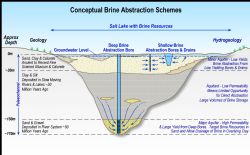
The program generated wide intercepts of high-grade potash (9kg/m3 - 11kg/m3) to depths of 135m (down-hole), which was the depth capacity of the drill rig used. This seismic survey program, and the program completed in late 2015iii, pave the way for clear targeting of drill holes into the deepest parts of the palaeovalley, allowing Goldphyre to assess the characteristics of the sand layers traditionally found in the bottom strata of the palaeovalley sediments (Figure 1 in link below). This coarse, unconsolidated material often has a high permeability, which facilitates drainage of the overlying hydrogeological units.
Goldphyre is finalising plans to conduct another drilling program at the Lake Wells Potash Project. This program will be aimed at understanding the sand, or basal layer, found at the bottom of the palaeovalley (Figure 1 in link below).
In addition, the Company is working to complete an Exploration Target for release during Q1 2016.
Using the results of the planned drilling program, Goldphyre plans to release a maiden resource estimate in H1 2016.
Goldphyre considers it important to publish resource estimates that reflect only the amount of potash that can ultimately be recovered, because this is the figure that will drive the project's production rates, capital and operating costs, and other key economics. Moreover, this approach is consistent with JORC requirements to report only resources for which there is a reasonable prospect of economic abstraction.
At the same time however, to allow for resource comparison with its peers, the Company will also discuss its estimates of in-situ potash volume based on total porosity measures, which ignore true or actual extractability of the brine.
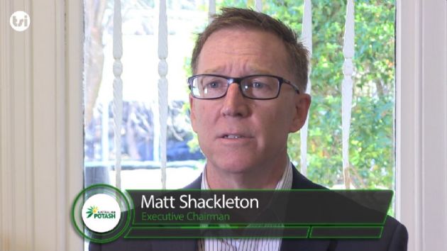
Goldphyre Executive Chairman Matt Shackleton said the full set of seismic results supported the Company's view that the Lake Wells Potash Project had strong potential to host a substantial potash resource.
"We confirmed with our first drill program, and then with our first seismic program, that the Lake Wells Potash Project comprises a major palaeovalley of significant depth and breadth, and with high grades of potash," Mr Shackleton said.
"With this latest seismic program, we have extended the interpreted length of the palaeovalley significantly. It is also important to note that this work is yet to identify the end of the palaeovalley.
"The outstanding potential of the Lake Wells Potash Project is becoming clearer with every round of work we do. We look forward to delivering a maiden resource in the first half of 2016, a key step in achieving our target of commencing a low capital operation supplying Australian farmers with a product they currently import 100 percent of from costly overseas suppliers."
TECHNICAL DISCUSSION
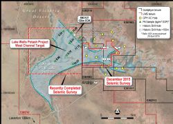
A second passive seismic survey was completed on the LWE playa lake area, which adjoins the Goldphyre tenure (Figure 2 in link below). The survey work consisted of 208 stations recorded by Tromino 3G units with processing completed by Perth based Resource Potentialsiv.
The passive seismic survey was aimed at mapping interpreted depth of transported cover, the form of the interpreted palaeovalley system extending westwards and if possible, highlight the thalweg, or basal section of the palaeovalley that may likely comprise significant palaeochannel coarse-grained quartz sand and grit. The success of the survey to vector in on the deepest section of the palaeovalley in order to assist deep drill targeting for potash brine has been achieved.
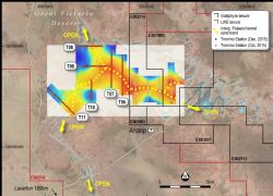
The generated survey data was good quality and with calibration against existing drill holes with known depths to basement (Figure 2), interpretive work has successfully delineated an approximately east-west trending palaeovalley that extends westwards from the GPH tenure and splits into two significant palaeovalleys that trend to the north and south (Figure 3 in link below). The nominal section line spacing was approximately 1,200m with station centres at 100m-200m. The peak H/V (Horizontal/Vertical) frequencies show a good correlation coefficient and also show reasonable shear wave velocity in the palaeovalley fill.
It is important too that the outer traverses (T08, T11: Figure 3) also show an interpreted, well-developed deep (~100m) palaeovalley profile, indicating the palaeovalley system extends further northward and southward on the LWE tenure. Based on all the traverses from the two seismic surveys combined, the interpreted palaeovalley length inclusive of the north and south branches on the LWE tenure is approximately 20km.
The seismic modelling on some sections indicates depths of up to 150m-170m (Figures 4 - 9) for the base of the palaeochannel are likely. Several aircore (AC) holes completed by Goldphyre in the July 2015 drill program reached considerable depths (up to 141m, the extent of the drilling rig's depth capacity) but did not penetrate through the transported sediments to basement.
The latest results with interpreted depth ranges and clear trend directions over an extensive area of the playa lake system will be instrumental in targeting the basal palaeochannel sand potential for the upcoming drill program.
To view all figures, please visit:
http://media.abnnewswire.net/media/en/docs/ASX-GPH-752006.pdf
About Australian Potash Ltd
Australian Potash Limited (ASX:APC) is an ASX-listed Sulphate of Potash (SOP) developer. The Company holds a 100% interest in the Lake Wells Potash Project located approximately 500kms northeast of Kalgoorlie, in Western Australia's Eastern Goldfields.
Following the release of a Scoping Study in 2017, APC has been conducting a Definitive Feasibility Study (DFS) into the development of the Lake Wells Potash Project. The Company is aiming to release the findings of the DFS in H2 2019.
The Lake Wells Potash Project is a palaeochannel brine hosted sulphate of potash project. Palaeochannel bore fields supply large volumes of brine to many existing mining operations throughout Western Australia, and this technique is a well understood and proven method for extracting brine. APC will use this technically low-risk and commonly used brine extraction model to further develop a bore-field into the palaeochannel hosting the Lake Wells SOP resource.
A Scoping Study on the Lake Wells Potash Project was completed and released on 23 March 2017. The Scoping Study exceeded expectations and confirmed that the Project's economic and technical aspects are all exceptionally strong, and highlights APC's potential to become a significant long-life, low capital and high margin sulphate of potash (SOP) producer.
| ||
|


