Seismic Survey Defines Deep Palaeovalley Highlighting Significant Potential of the Lake Wells Potash Project
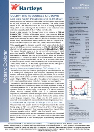
Perth, Dec 15, 2015 AEST (ABN Newswire) - Goldphyre Resources Limited ( ASX:GPH) is pleased to advise that a recently completed seismic survey has provided more strong evidence that its Lake Wells Potash Project in WA's eastern goldfields has the potential to host a substantial potash resource.
Highlights:
- Seismic survey conducted across Goldphyre's Lake Wells Potash Project confirms presence of extensive palaeovalley up to 170m deep
- A deep palaeovalley is significant: the sediments that infill the palaeovalley form an alluvial aquifer which hosts the high-grade potash brine
- Deeper sediments provide an opportunity for deeper pumping-water levels and potentially increased potash recovery
- And pumping from sand, which commonly occurs at the bottom of the palaeovalley sediments, facilitates drainage of the potash brine from the overlying sediments
- Peak depths surveyed range from 150m - 170m with the base of sediments clearly delineated, allowing Goldphyre to accurately target the deepest sections of the palaeovalley in planned follow up drilling
Next Steps:
- Co-funded EIS drilling to commence Q1 2016
- Seismic survey currently underway on adjacent tenure recently acquired through the potash agreement with the Mark Creasy controlled Lake Wells Exploration Pty Ltd
- Exploration Target for release early 2016: maiden Resource on track for H1 2016
LAKE WELLS POTASH PROJECT
Confirmation of the palaeovalley's size is important because it will underpin the calculation of an Exploration Target for the project, 500km north-east of Kalgoorlie, early next year.
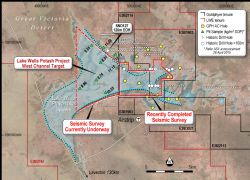
The results of this seismic survey are also important because they support Goldphyre's theory that the palaeovalley, and the high-grade sulphate of potash ("SOP") mineralisation hosted within the brines in the palaeovalley, extend onto the recently acquired neighbouring tenements. Goldphyre has this week started a seismic program on these adjoining tenements to establish the extent and contour of the palaeovalley on this ground.
Goldphyre announced on 2 December 2015 that it had tripled the size of the Lake Wells Potash Project by acquiring the potash rights on the adjoining tenements. A company controlled by prospector Mark Creasy holds these tenements.
The transaction will see Mr Creasy's Yandal Investments Pty Ltd emerge with a 19.9% interest in the Company.
The drilling program conducted at Lake Wells in July identified high-grade potash mineralisation both beneath the lake and the low dunes surrounding the lake.
The program generated wide intercepts of high-grade potash (9kg/m3 - 11kg/m3) to depths of 135m (down-hole).
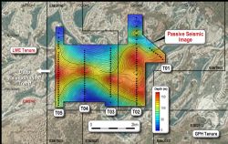
The seismic survey program completed recently generated data and imaging (Figures 2, & 4 - 8, see link below) that permits the clear targeting of drill holes into the deepest parts of the palaeovalley, allowing Goldphyre to assess the characteristics of the basal sand layers traditionally found in the bottom strata of the palaeovalley sediments. This coarse, unconsolidated material often has a high permeability, which facilitates drainage of the overlying hydrogeological units.
Following completion of the Exploration Target early next year, Goldphyre plans to commence a core-drilling program and field pumping trials in preparation for a maiden resource estimate by the middle of 2016.
The upcoming drilling program will be used to estimate vital brine resource parameters, including specific yield and permeability. This in-depth assessment is important because it will help determine the percentage of the total brine resource that can be drained and therefore the amount of potash that can be recovered.
Goldphyre believes it is more meaningful to publish resource estimates which reflect only the amount of potash that can ultimately be recovered because this is the figure which will drive the project's production rates, capital and operating costs and other key economics.
Goldphyre Executive Chairman Matt Shackleton said the seismic results supported the Company's view that the Lake Wells Potash Project had strong potential to host a substantial potash resource.
"Confirmation of a major palaeovalley at the Company's project means we have ticked another key box in our strategy to establish a significant potash resource," Mr Shackleton said.
"When the current seismic program on the adjoining tenements is completed and combined with our earlier drilling results, we will have more than enough confidence to set an Exploration Target.
"This will then give us a clear pathway to establishing a maiden resource and undertaking further detailed field and metallurgical test work which will help underpin the project's economics."
TECHNICAL DISCUSSION
A passive seismic survey was completed on the 100 per cent held Goldphyre tenure at the Lake Wells Potash Project (Figure 1, see link below). The survey work consisted of 120 stations recorded by Tromino 3G units, and processing was completed by Perth based Resource Potentials.
The passive seismic survey was aimed at mapping depth of transported cover with the aid of existing historic drill coverage, and if possible, highlight the thalweg, or basal section of the palaeovalley. The Company aimed to vector in on the deepest section of palaeovalley in order to assist deep drill targeting for potash brine. This has been achieved.
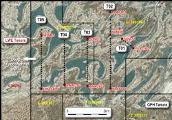
The survey data generated was of very good quality and with calibration against existing drill holes with known depths to basement (Figure 3, see link below), has successfully delineated an approximately east-west trending palaeovalley on five survey section lines (Figure 2). The section line spacing was approximately 1200m with station centres at 100m-200m. The peak H/V (Horizontal/Vertical) frequencies show an excellent correlation coefficient and also show very uniform shear wave velocity in the palaeovalley fill.
The modelling shows that depths of approximately 150m-170m (Figure 4 - 8) for the base of the palaeochannel.
Several aircore (AC) holes completed by Goldphyre in the July 2015 drill program reached depths of 141m (the extent of the drilling rig's depth capacity), and terminated in transported sediments.
To view the release including figures, please visit:
http://media.abnnewswire.net/media/en/docs/ASX-GPH-746510.pdf
About Australian Potash Ltd
Australian Potash Limited (ASX:APC) is an ASX-listed Sulphate of Potash (SOP) developer. The Company holds a 100% interest in the Lake Wells Potash Project located approximately 500kms northeast of Kalgoorlie, in Western Australia's Eastern Goldfields.
Following the release of a Scoping Study in 2017, APC has been conducting a Definitive Feasibility Study (DFS) into the development of the Lake Wells Potash Project. The Company is aiming to release the findings of the DFS in H2 2019.
The Lake Wells Potash Project is a palaeochannel brine hosted sulphate of potash project. Palaeochannel bore fields supply large volumes of brine to many existing mining operations throughout Western Australia, and this technique is a well understood and proven method for extracting brine. APC will use this technically low-risk and commonly used brine extraction model to further develop a bore-field into the palaeochannel hosting the Lake Wells SOP resource.
A Scoping Study on the Lake Wells Potash Project was completed and released on 23 March 2017. The Scoping Study exceeded expectations and confirmed that the Project's economic and technical aspects are all exceptionally strong, and highlights APC's potential to become a significant long-life, low capital and high margin sulphate of potash (SOP) producer.
| ||
|


